Lithium One Metals
Suite 1680 - 200 Burrard St.,
Vancouver, British Columbia V6C 3L6
[email protected]
Root Area Projects
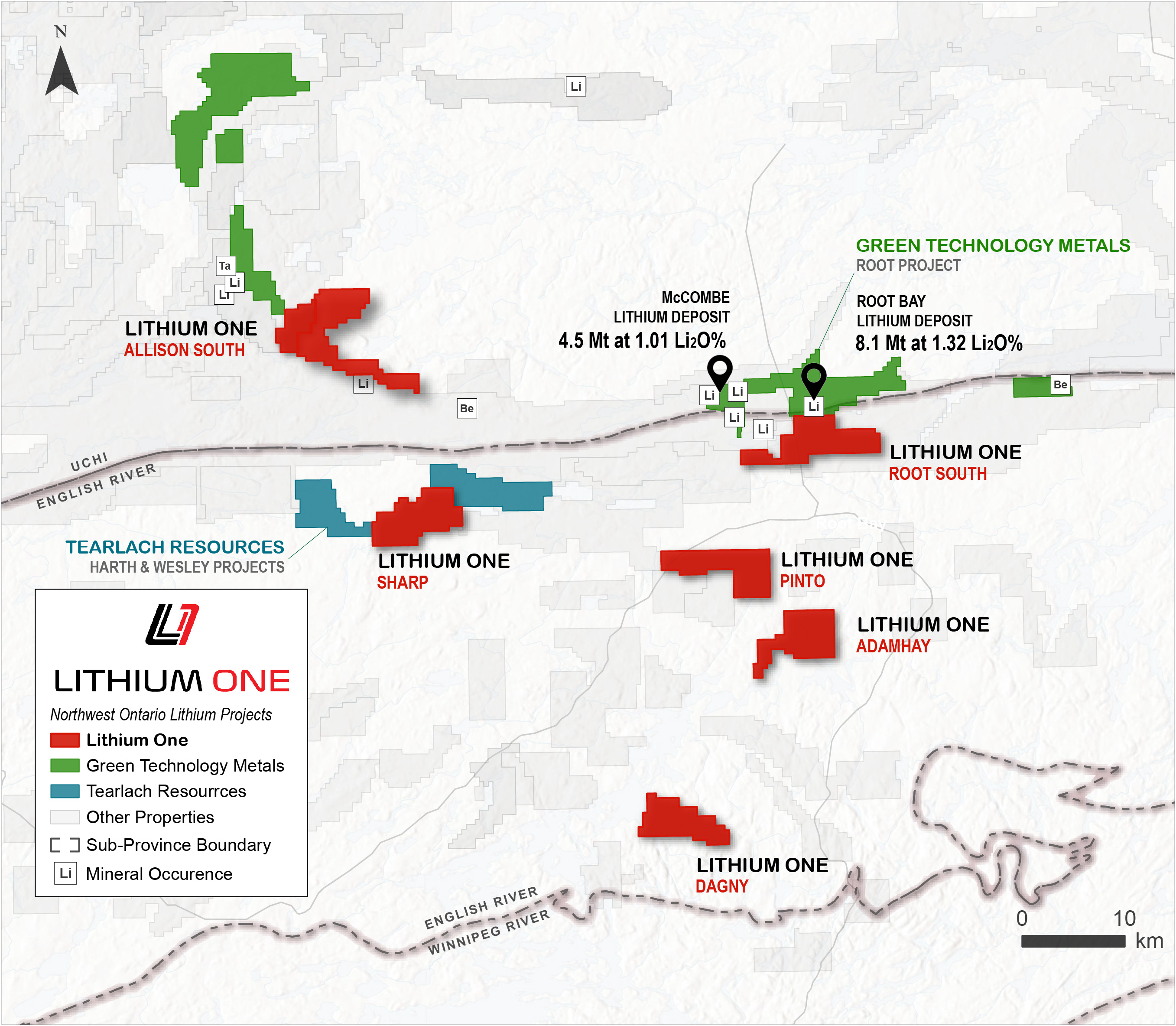
Lithium One holds six properties in the Root area of Northwest Ontario covering over 19,000 ha. The properties have mapped pegmatite and are located near subprovince boundaries in an emerging lithium district. Lithium deposits in Canada are overwhelming located within 20 km of subprovince boundaries that act as conduits for fertile peraluminous granites.
Figure 1: Lithium One's Root Area Projects
Root South
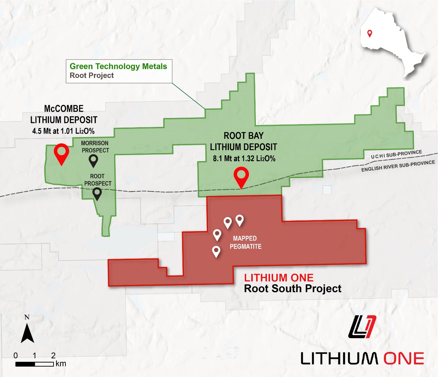
The Root South Lithium Project is adjacent to the Root Project, which is owned by Green Technology Metals (ASX:GT1) who recently announced a resource at Root Bay of 8.1 Mt at 1.32% Li2O, along with their resource at McCombe of 4.5 Mt at 1.01% Li2O. The Project is in a highly prospective location 1 km from the Uchi and English River subprovince boundary and underlain by peraluminous S-type fertile granites. The Root Lake LCT pegmatite group is mapped nearby and muscovite-tourmaline bearing pegmatites which have not been explored for lithium are mapped on property. The project is comprised of 3,570 ha in Red Lake Mining District with year round road access.
Figure 2: Lithium One's Root South Project
Allison South
The Allison South Lithium Project is in the Red Lake Mining Division, 100 km east of Red Lake, Ontario with good highway and logging road access. It is adjacent to the Allison Lithium Project owned by Green Technology Metals (ASX:GT1), and 40 km southeast of their Root Lithium Project. It consists of 242 claims covering 4,922 ha. The project is underlain by the Allison Lake Batholith, a peraluminous, S-type fertile granite with multiple pink and white pegmatites mapped on the property and registered lithium mineral occurrences on trend to the northwest and southeast. The margins of the batholith have been identified by government mapping as an underexplored and highly prospective area.
Figure 3: Allison South, Sharp, and Root South Projects with Elevated Lithium Trend (Open File Report 6099)
Sharp
The Sharp Lithium Property is comprised of 3,225 ha in the Red Lake Mining District with access to the project via logging roads. The property is adjacent to the Wesley and Hearth Lithium projects owned by Tearlach Resources. It is approximately 4 km from the boundary between the Uchi and English River subprovinces and underlain by peraluminous S-type fertile granites. Previous mapping has identified prospective pegmatites which have not been explored for lithium
Pinto
The Pinto Lithium Property covers 2,064 ha and 150 cell claims in the Red Lake Mining District . The property is 13 km to the south of the Uchi and English river subprovince boundary and located on the contact between peraluminous S-type fertile granite and metasediments. The property is road accessible.
Dagney
The Dagny Lithium Property consists of 123 claims totaling 2,515 ha. The is located 8 km from the terrain boundary between the Winnipeg River Subprovince and the English River Subprovince and is underlain by peraluminous S-type fertile granite and metasediments which make excellent exo-contact hosts for fractionating parental granites. Pegmatites have been previously mapped on the property, and northeast trending structures mapped across the property are high priority to investigate as conduits for parental melts.
Adamhay
The Adamhay Lithium Property consists of 138 claims totaling 2,813 ha. The property is located 19 km from the terrain boundary between the Uchi Subprovince and the English River Subprovince and is underlain by peraluminous S-type fertile granite and metasediments which make excellent exo-contact hosts for fractionating parental granites. Pegmatites have been previously mapped on the property, and northeast trending structures mapped across the property are high priority to investigate as conduits for parental melts.
Carl Ginn, P.Geo., has approved the information contained in this presentation. Mr. Ginn is a Qualified Person pursuant to National Instrument 43-101.


